
Map from Ptolemy as reproduced in 16th century. This busts so many myths pushed by colonial fux and Rome Leelas. This is a long thread.
Map was drawn in 2nd century and kept as a secret. Till Portuguese stole the map. Yes. There was no romantic seafaring. No sailing to the unknown. No valor. No Originality. Just the steal like Dum Diversa.
Details of the theft: The map is based on the "Cantino Planisphere" (1502), a secret Portuguese manuscript world map stolen from Lisbon by an agent of Ercole I d'Este, Duke of Ferrara.
The map, once a closely guarded secret, was widely disseminated across Europe after its theft.
The map, once a closely guarded secret, was widely disseminated across Europe after its theft.
I have already provided you with map which great fraudster called Columbus used for his seafaring. You already know Columbus was not trying to find a sea route to India. Because that map clearly showed his destination was not India. Check the reference to that thread in the end.
However, now you know that Ptolemy wrote about India and mapped various ways to get to India in 2nd century. So seafaring was already known. Now let me zoom out little bit and show you what Ptolemy knew in 2nd century.
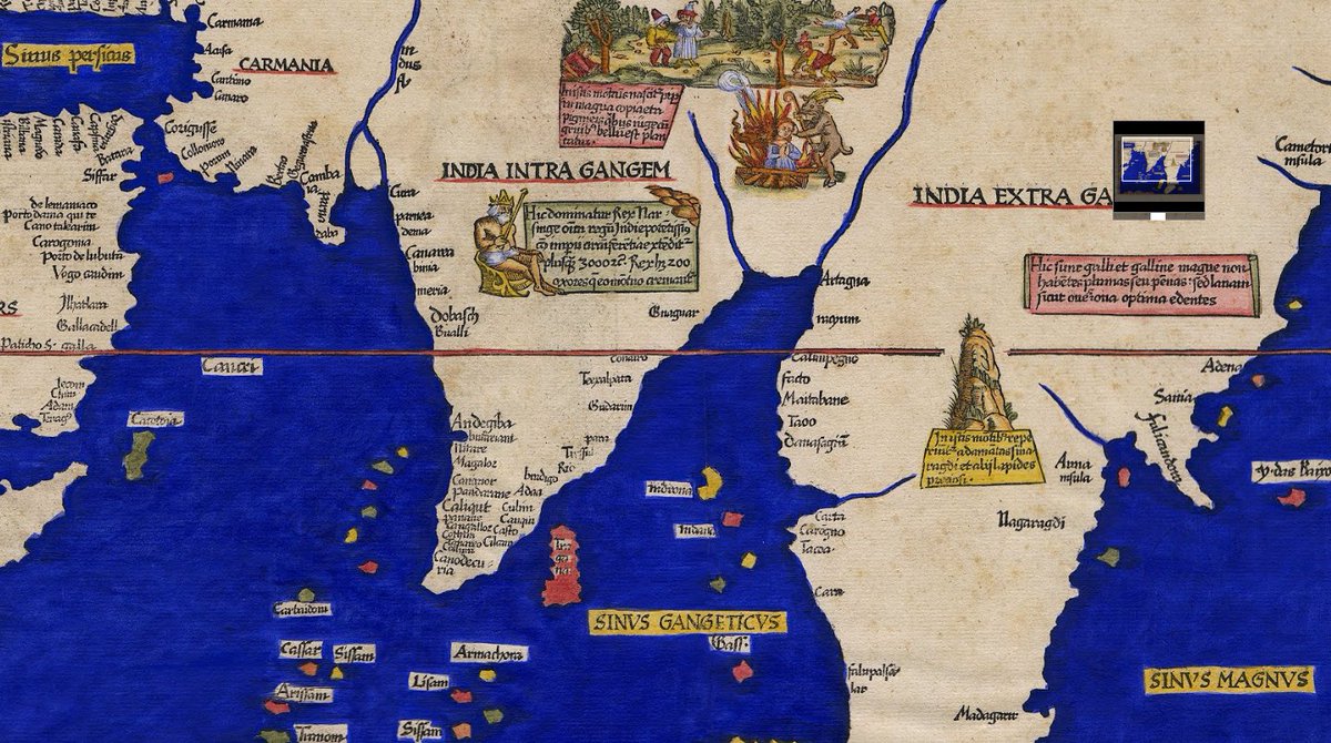
As you can see emphasis was traveling to India. India was shown as vast land divided into two regions. Here are all the numbers I have marked on the map.
1. India near Ganges
2. Gulf of Ganges (Bay of Bengal)
3. India far from Ganges (current day Burma, Malaysia and part of Indonesia)
4. Big gulf (could be South China Sea)
5. River Ganges
6. River Indus ( Now you can see Indian peninsula between Ganges and Indus)
7. Srilanka ( Remember I told you guys that Megasthanes visited South India and not North) . Megasthanes mentions Srilanka was huge. Check that thread too.
Contd...
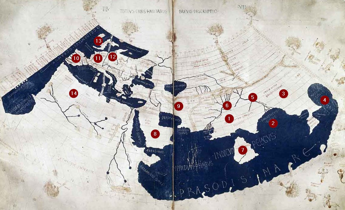
8. Arabia
9. Persia
10. Spain
11. France
12. Germany
13. England
In Europe you can also see the boot shaped Italy and near Italy Greece too is shown.
8. Arabia
9. Persia
10. Spain
11. France
12. Germany
13. England
In Europe you can also see the boot shaped Italy and near Italy Greece too is shown.
All this was from 2nd century. Sea faring was already there. Only thing Ptolemy did not know was there is ocean surrounding Africa. I have marked Africa with 14. Ptolemy called it Libya and it showed like a big land mass south of Europe.
However Indian Ocean was teeming with trade. How come! Why so many places shown navigable near India but Europe is stuck north of Africa which basically the edge of the world!
This is an additional myth busting moment for the myth of European navigation! They knew nothing. Whereas Indians had navigated all the way to Europe, China, Far East Asia, Arabia, Mediterranean all even before 3rd century CE!
Now comes the other surprise. I have written here about how Indian used Socotra to trade with Africa. Once the trade started, it is very likely that Indian reached west coast of Africa. However I will leave it my African friends to take colonials to the cleaners. My reasoning today was to share the details of Ptolemy's map to open all your minds for the greatness of Bharat.
To do this, I am now zooming in to Bharat.

Here are some of the names found on the map, along with their possible modern equivalents:
India Intra Gangem: This refers to the region "India within the Ganges," which denotes the part of India to the west of the Ganges River.
India Extra Gangem: This refers to the region "India beyond the Ganges," which denotes the region to the east of the Ganges River, often understood to include parts of modern-day Bangladesh and Myanmar.
Carmania: Likely corresponds to the modern-day region of Kerman in Iran.
Barbaria: Could be referring to the Horn of Africa region, encompassing parts of modern-day Somalia and Ethiopia.
Sinae: Refers to China.
Syrus Magnus: Could be referring to the Persian Gulf or the larger oceanic area around it.
Magnus Sinus: Refers to the "Great Gulf," likely referring to the modern-day Bay of Bengal.
Palibothra: Likely corresponds to modern-day Pataliputra, which is Patna in Bihar, India.
Modoura: Might correspond to Madurai in Tamil Nadu, India.
Colchi: This could refer to the Kutch region in Gujarat, India.
Ceylon: This is the ancient name for Sri Lanka.
Argyre: Often speculated to refer to a mythical silver-rich island, possibly an early reference to Sumatra or another island in Southeast Asia.
Sinae Magnus: Refers to the "Great China," corresponding to the modern-day territory of China.
Bariyaza: This might correspond to Baruch (Bharuch) in Gujarat, India.
Tabrobana: Refers to Sri Lanka.
These names and their interpretations are based on historical and geographical research, and some identifications remain speculative. Ptolemy's map is valuable for understanding ancient geographical knowledge and the perceptions of different regions in antiquity.
Now the details of the above map.
Details of the Map:
Title: India and East Asia
Creator: Lorenz Fries
Date Published: Mid 16th Century
Location Created: Lyon
Physical Dimensions: 30 x 47.5 cm
Type: Document
Medium: Woodcut with hand coloring
Original Title: Tabula Nova utriusque Indiae
Details of the Map:
Title: India and East Asia
Creator: Lorenz Fries
Date Published: Mid 16th Century
Location Created: Lyon
Physical Dimensions: 30 x 47.5 cm
Type: Document
Medium: Woodcut with hand coloring
Original Title: Tabula Nova utriusque Indiae
Map from the mid-16th century, created by Lorenz Fries, that represents India and East Asia. This map is notable for being one of the first to depict India in its modern form as a recognizable peninsula, based on a stolen Portuguese master map. Here are some key points from the text:
Map Description:The map covers all of South Asia and much of East Asia as conceived by Europeans near the beginning of the 16th century.
It names India as "India Intra Gangem" (India within the Ganges) and "India Extra Gangem" (India beyond the Ganges).
The depiction of India includes the Indus River and the Ganges River as its boundaries.
Now comes the interesting part. I was surprised that many of the names on this map (further zoomed) are still a mystery to Indologist but were a cake walk for me because of the special insight God is giving me. So here I go. I just surprised an Indologist when I mapped most of the names between 10 to 22 even without looking at modern map!
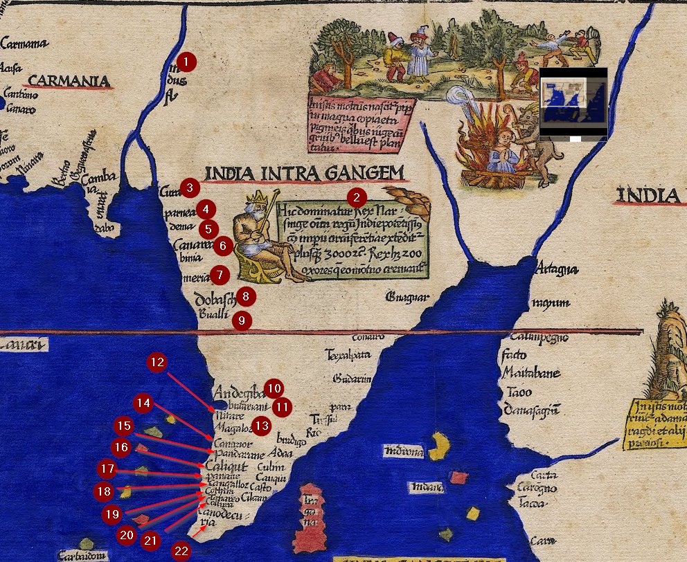
1 as you know is River Sindhu.
10. Andegiba is Honnavara
11. Budfemani: This name is unclear but most likely Bhatkal
12. Nitare - is Netravati River just before
13. Magaloz - Mangalore
14. Canaor is Kannur
15. Pandocrene is probably Mahe
16. Caliqut is Calicut
17. Panani is Ponnani
18. Cangaloz is Kodangallur
19. Cotoha is Kochi
20. Tanaveo is not clear to me -- Allapuza
21. Colium is Kollam
22. Canodecuria is KanyaKumari.
Look how beautifully this historical map is accurate for the placement of all the cities we know and we grew up in. Understand we have been hoodwinked into believing that we were born to serve the Dum Diversa.
Understand maritime history of India. Shake off Dum Diversa.
Shake of colonialism.
Unite.
Utthistha Bharathaha.
Shake of colonialism.
Unite.
Utthistha Bharathaha.
Thank you for your time. Our history needs to accurately depict what happened to our ancestorts. That is the only way to ensure Bharat rises once again. Will update this thread with tidbits and references throughout this week. Bookmark this and keep coming back.
Loading suggestions...