

Datums and map projections are fundamental concepts in the fields of remote sensing, GIS and surveying that play a critical role in accurately representing the Earth's surface in two dimensions.
#geospatial
#geospatial
A datum is a reference system used to define the positions of geographic features on the Earth's surface. It consists of a coordinate system (latitude and longitude) and a reference point (geodetic control point) on the Earth's surface.
Types:
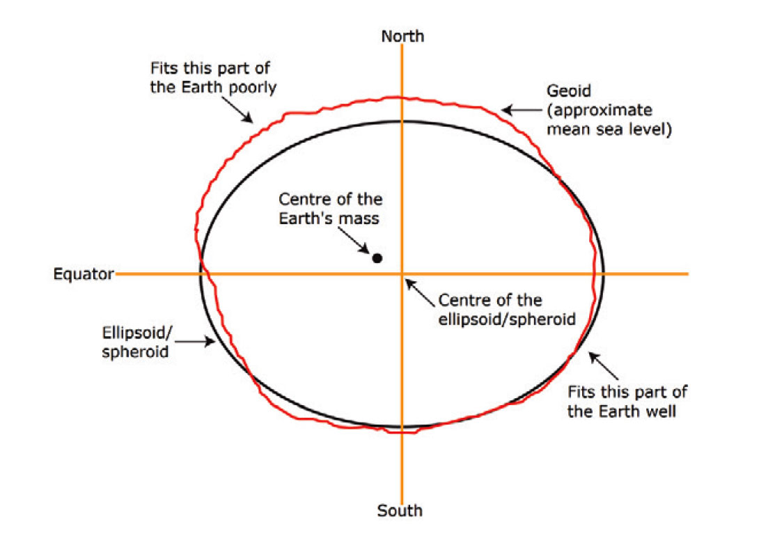
Horizontal Datum: This refers to the position of a point on the Earth's surface in terms of latitude & longitude (eg., WGS84).
Vertical Datum: This refers to the elevation/height of a point on the Earth's surface. A common vertical datum is the Mean Sea Level (MSL) datum.
Horizontal Datum: This refers to the position of a point on the Earth's surface in terms of latitude & longitude (eg., WGS84).
Vertical Datum: This refers to the elevation/height of a point on the Earth's surface. A common vertical datum is the Mean Sea Level (MSL) datum.
A map projection is a mathematical model used to represent the three-dimensional surface of the Earth on a two-dimensional map. Different projections have different properties, and the choice of projection depends on the purpose of the map and the region being represented.
Types of Map Projections:
Cylindrical Projections: These project the Earth's surface onto a cylinder and are best for equatorial regions. Examples include the Mercator and Transverse Mercator projections.
Cylindrical Projections: These project the Earth's surface onto a cylinder and are best for equatorial regions. Examples include the Mercator and Transverse Mercator projections.
Conic Projections: These project the Earth's surface onto a cone and are suitable for mid-latitude regions. Examples include the Albers Equal Area and Lambert Conformal Conic projections.
Azimuthal Projections: These project the Earth's surface onto a plane and are useful for polar regions. The stereographic and Lambert Azimuthal Equal Area projections are examples.
The choice of map projection depends on the purpose of the map and the region being represented. Equidistant projections are suitable for measuring distances accurately, while conformal projections preserve angles, and equal area projections maintain relative sizes.
No projection is perfect, and all introduce some form of distortion in properties like shape, size, distance, or direction. Understanding these distortions is crucial when choosing a projection for a specific application.
Remote Sensing, GIS, and Surveying Applications:
Remote Sensing: Remote sensing data, such as satellite imagery, is often processed and analyzed in GIS software. Accurate georeferencing using datums and projections is essential for overlaying and analyzing remote sensing data.
Remote Sensing: Remote sensing data, such as satellite imagery, is often processed and analyzed in GIS software. Accurate georeferencing using datums and projections is essential for overlaying and analyzing remote sensing data.
GIS: GIS systems manage, analyze, and visualize geospatial data. Datums and projections ensure data compatibility and accurate spatial analysis.
Surveying: Land surveyors use datums and map projections to accurately measure and represent land features and boundaries. Surveying instruments are often equipped with GPS technology to ensure precise positioning.
You can read more of Datums and Projections in this book:
whittlespublishing.com
whittlespublishing.com
Loading suggestions...